Bunkers and Borders: Tracing Fortifications and Shelters around Liberec and the Tripoint
Around Liberec, prewar concrete capsules sit just steps from modern bike paths and the border runs along the Nysa Łużycka toward the point where three countries meet. This guide shows how to read light field fortifications on the ground, how to fit a visit to Liberec’s civil-defense shelter and the “Bunkr Studánka” into short borderland loops, and where to view the whole story from above — from the Ještěd ridge.
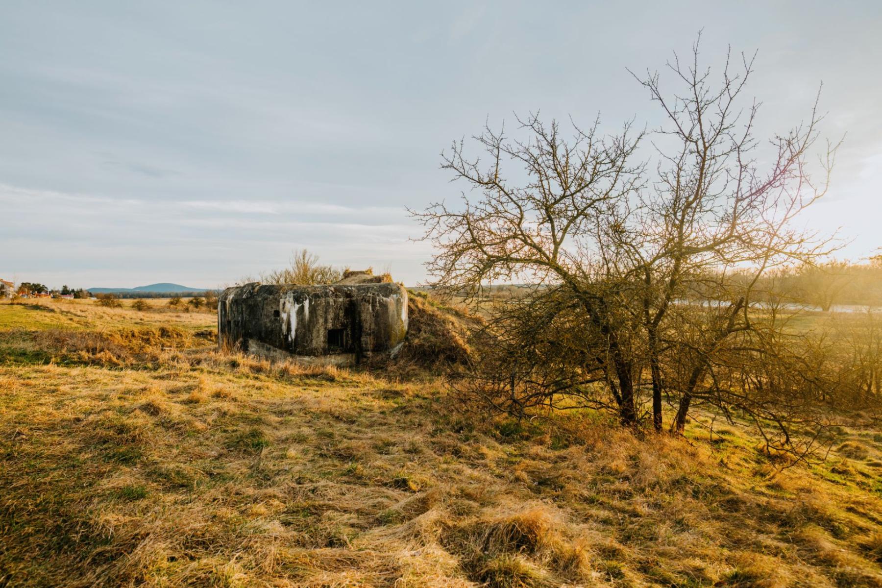
Concrete in the woods has its own smell: dampness, moss and the shadow of camouflage paint peeling off in strips. In the shade of beeches, at the edge of a meadow, you suddenly spot the low outline of a wall and the characteristic slit of a firing embrasure. A few kilometres on, the river speaks in the voice of a border. And when the silver cone of Ještěd’s hotel–television tower lights the horizon, you realize that here, around Liberec, 20th‑century history still lies within arm’s reach — literally.
Field lesson: how the line of light fortifications worked
Between 1935 and 1938 Czechoslovakia built, along its borders and on selected directions inland, a system of fortifications meant to slow a surprise attack and give the army time to mobilize.[1] Two worlds were plugged into the landscape: “heavy” works with artillery and full support facilities, and hundreds of smaller, light firing shelters — today the most commonly encountered concrete on the edges of fields, in woods and on the moraine humps around Liberec.
What will you see on site? Above all the logic of flanking fire. Light positions were designed so the main fire ran along the attacker’s line of approach, not straight ahead — which is why their embrasures aim “diagonally” rather than centrally forward. The thickest was the frontal wall, covered with a mound of stones and earth. In front of it were placed anti‑infantry and anti‑tank obstacles meant to draw an attacker into crossfire from neighbouring shelters.[1] Inside the same language of detail repeats: a tiny hole in the armoured plate for the barrel and sight, a periscope for observation, a hand ventilator, grenade launchers to defend the entrance. When you stand at an embrasure and lay your hand on the cold steel, you understand that the scale was “human” — three, four, maybe seven people in a crew.
Pay attention to the camouflage. Concrete was often covered with turf or painted in blotches; entrance doors were hidden behind wall folds. Don’t look for monumental architecture — watch for small anomalies: a simple ledge in a bank, a flat boulder among the grass, a beaten path that leads nowhere. These are the traces of a line that — looking at a map — is easy to miss, but in the field you feel it almost underfoot.
Liberec underground and “Bunkr Studánka”: the feel of material
The simplest way to peek inside follows two routes. The first is the municipal civil‑defense shelter in Liberec (kryt civilní obrany), which offers guided entries. This is not a heritage “gem” but a living piece of infrastructure — with air filtration, an engine, narrow corridors and period signage. Entering that tunnel of history sharpens the focus: the difference between a 1930s military bunker and a civil‑defense Cold War facility becomes suddenly obvious, even if some technical details sound similar. Opening hours and tour languages can be seasonal, so it’s worth checking current times at the Liberec Municipal Tourist Information Centre before you go.
The second route leads out into the field — to the Krásná Studánka district north of town, where a local initiative has reconstructed a light bunker known as “Bunkr Studánka”. It’s one of those objects that — rebuilt with an attention to detail — lets you examine the layout of embrasures, the entrance with its shield, and how the wall thickness “works” up close. It is open on selected days and for events, and when the door is closed it’s still worth approaching to learn how to “read” the mass from the outside. Look for camouflage traces and check how the shelter is integrated into the slope — usually so that it disappears into the background.
In practice, a visit to either place pairs well with a short walk nearby. Within a few kilometres on foot you’ll usually find another “node” of the former line. Switch to the rhythm of small discoveries: the sound of gravel underfoot on a woodland shortcut, the scent of resin, the cool air at a shelter entrance that holds shadows longer than the grass growing around it.
The tripoint on the Nysa: a border that flows
In the north‑west of the region, between Czech Hrádek nad Nisou, German Zittau and the Polish border, the states meet at a single point. Formally it’s the Tripoint of Poland, the Czech Republic and Germany on the Nysa Łużycka — a place that encapsulates this whole guide: a history of divisions, contemporary freedom of movement and a very tangible landscape of river, meadows and embankments.[4] On the Czech side you’ll find information boards and modest tourist infrastructure; on the German and Polish sides there are good terrain approaches and convenient access roads. You don’t need a major expedition: from the centre of Hrádek nad Nisou you can reach it on foot or by bike, following paths along the water.
It’s worth standing on the bank and “reading” the place like a map. The Nysa Łużycka has long been a line — once an important political boundary, today also an axis of cross‑border cooperation. It is here, at the heart of the Euroregion Nysa–Nisa–Neisse, that neighbourly everyday life begins: cycle routes run as if unhindered through three countries, and city events fold this spot into the calendar without ceremony.[5] If you want to close the day’s historical loop, the tripoint is its symbolic clasp.
Panorama from Ještěd: borders laid out like a palm
There are views that order a whole trip in the head. In Liberec that job is done by Ještěd — the slender hotel–television tower on the ridge, the work of architect Karel Hubáček from the turn of the 1960s and ’70s.[2] Its hyperboloidal silhouette has the charm of a futuristic sculpture and the coolness of engineering precision. Inside there’s a restaurant and hotel, but above all it’s an excellent platform for “reading” the landscape: from the viewing terrace your gaze easily reaches north toward Lower Silesia and west toward Saxony.[2] In favourable conditions the horizon arranges itself into a story: the dark arcs of the Jizera Mountains’ forests, the shining surfaces of reservoirs, the ribbon of the Nysa, and somewhere far off — the low line of the Silesian–Lusatian Plain.
Practical note: the historic Ještěd cable car, which linked the lower station in Horní Hanychov with the summit, has been suspended indefinitely since the 2021 accident — check the current status before you travel.[3] Walking up is not difficult and offers the additional pleasure of watching the tower grow with every bend until it becomes the axis of the whole panorama.
Three weekend loops: traces of the line and urban life
Loop 1: Liberec — civil‑defense shelter — “Bunkr Studánka” — Liberec
Start in central Liberec. First, go underground with a guide: a few flights of stairs, the smell of dust and oil at the end of a corridor, the mechanical “music” of the ventilators. Then a short ride or walk to the northern outskirts, to Krásná Studánka. A visit to the reconstructed light shelter is a lesson in “plan and section” at 1:1 scale — you can walk around the mass, see how the entrance is closed and which way the embrasures point. We suggest returning to the centre through the green wedges between districts: you’ll suddenly find that the former line of fortifications, though “invisible”, leads you between ordinary suburban gardens.
Loop 2: Hrádek nad Nisou — Tripoint — riverside paths
This is the family option. From Hrádek nad Nisou’s square head for the river; the asphalt quickly turns into a field track by the embankments. The tripoint is a place more for being than for “sightseeing”: benches, a grassy bank, water flowing with only a few decimetres of level difference. Take a blanket, a thermos and let the kids count the border posts. If you want to lengthen the loop, route it along stretches on both banks — the sensation of being “between” is magnetic here.
Loop 3: Horní Hanychov — Ještěd ridge — borderland views
Start at the lower station of the former cable car. The trail immediately enters beech woods and crosses distinctive stony service roads. Turn around at intervals — the panorama of Liberec and its surroundings opens ever wider. On the ridge, go up to the viewing platform by the tower and try to put together what you’ve already seen: here — the Nysa and the tripoint, there — the line of hills where just a few hours earlier you were looking for shelters. Return the same way or by a neighbouring trail; in the evening the city lights arrange themselves into a soft web across the valleys.
What to look for to “see” more
- Arrangement of embrasures. If the embrasures look to the “side”, that is not a designer’s mistake but the logic of flanking fire. Try standing where a machine‑gun crew would stand — you’ll see how a neighbouring shelter covers a dead zone.[1]
- Wall thickness. The frontal wall is the most massive, banked and “buried” in the slope; the sides are often thinner. The front was built to take the worst, the rear to provide retreat and supply.
- Camouflage. Look for traces of paint, holes where nets were fixed, remnants of turf on the mound. Many objects were almost invisible from a few metres away.
- Contrast of eras. In Liberec’s civil‑defense shelter you’ll see filtration, power and a functional layout familiar from Cold War civil infrastructure. In 1930s light field shelters everything is subordinated to fire and surviving a short engagement.[1]
- Panorama as a key. Climbing Ještěd is not just about a “nice view”: from the terrace you’ll understand the geometry of the whole borderland — the river axis, the ridges, the layout of towns.[2]
This is not a checklist guide. It is more a proposal for attention. On the gentle bank of the Nysa in Hrádek nad Nisou the water goes quietly about its business as if borders did not exist. A few kilometres on, in the half‑light of Liberec’s shelter, the foreign language of technical inscriptions sounds like an echo of times when “everything” might have happened. And higher still, on Ještěd’s ridge, the light on the tower’s aluminium cladding is so pure that you stop arguing with history and simply look. Borders are tangible here — but they work most powerfully in the mind.


