Trails and rules at the tripoint: how to read PTTK and KČT markings and the regulations on the Polish, Czech and German sides of the Izery
Colors don’t indicate difficulty, and the border is not the end of the trail. A practical guide to reading PTTK and KČT signs and to the rules for moving through Polish forests, the Czech CHKO Jizerské hory and the German Naturpark Zittauer Gebirge — from Smrk to the PL–CZ–DE tripoint.
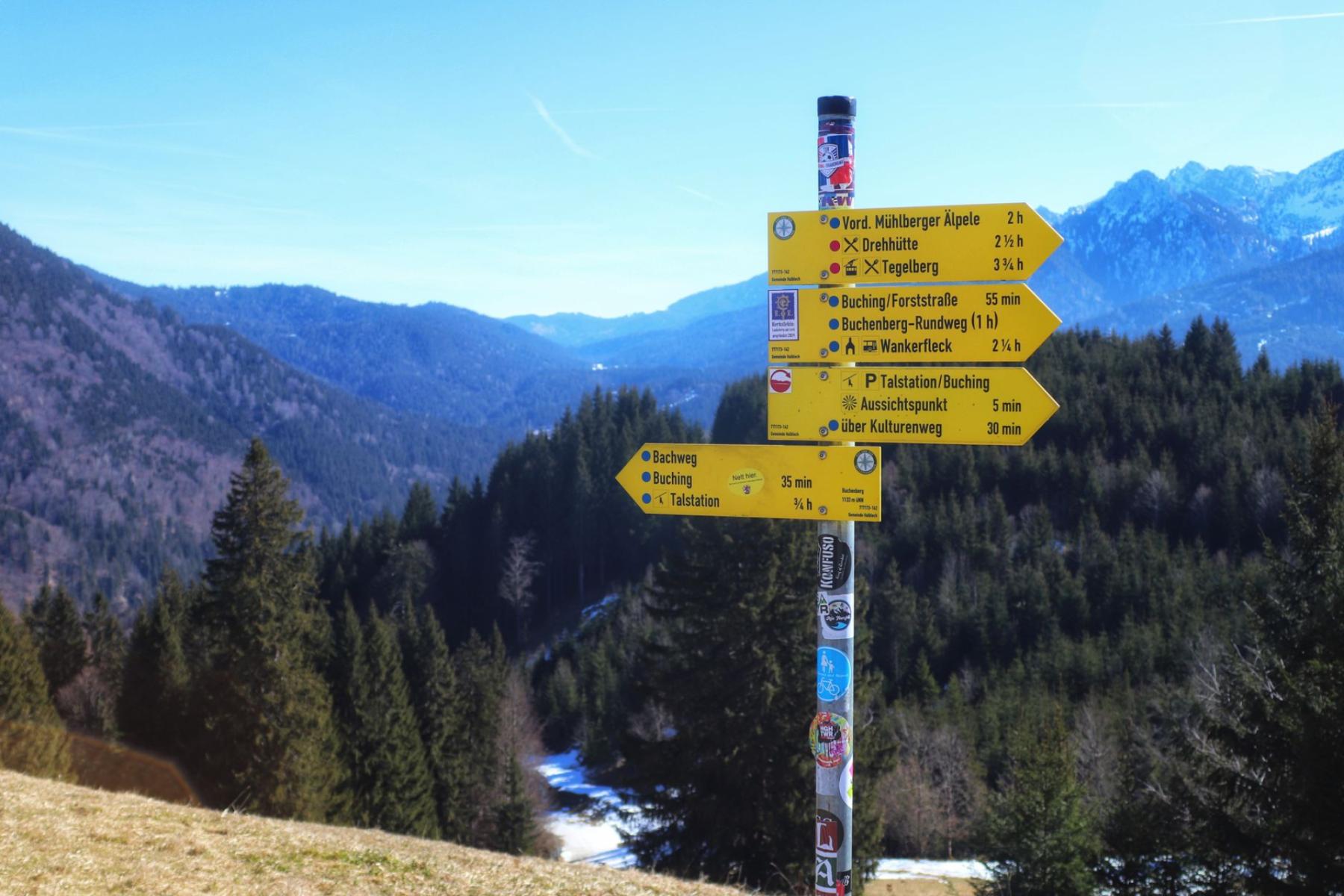
The first thing you notice on the Izera ridge is the cool scent of resin and wet bark. The second is a certain dissonance: the red PTTK stripes vanish and, beyond the pines, Czech white squares with colored centers begin to flash. A national border here is not the end of a trail but a change of alphabet. This guide teaches you how to read it without guessing, and what the law says on each side.
Polish PTTK bands: color plays a role, not difficulty
If on the Polish side you look at a rectangle with two white stripes and a colored one in the middle, you’re home. These are the classic PTTK signs painted on trees and rocks — a system in line with the family of Central European markings you’ll recognize just across the border too. In Poland five colors are used (red, blue, green, yellow, black), but — note — their meaning has nothing to do with difficulty. This myth has been confusing hikers for years. Difficulty is coded in our skiing signs, not on footpaths[6].
In practice this means that the red of the Main Sudeten Trail or a blue connector in a valley says nothing about exposure, chains or elevation gain. Color helps distinguish threads of the network and organize movement. Where a route turns sharply, you’ll see an arrow in the trail’s color. Where several routes meet, a sign can be “doubled.” From a Polish point of view the key thing to remember is: plan difficulty from the map and the profile, not from the sign’s color.
A good field test is to leave Świeradów-Zdrój on the red ridge toward Stóg Izerski and continue — everything is clear right up to the border. Then the alphabet changes, but the grammar remains surprisingly close.
Czech KČT: bands on a white background and the “rozcestníky”
After you pass the border posts, KČT comes into play — the system the Czechs have been proud of since the late 19th century. The basic rule is simple: a 10×10 cm square, white background, a stripe in one of four colors in the middle (red, blue, green, yellow). Direction changes are indicated with arrows of the same color; short spur routes to viewpoints or springs are marked with separate symbols[3].
It’s not just paint on trunks. The heart of the Czech “grammar” are junctions with directional plates — metal "směrovky" on signpost poles. Here the network’s logic is joined: the place name, arrows leading to the next nodes, often with an ordered hierarchy of colors. Even without knowing the language, the layout is readable and works like a simple interface — you look, match colors, go. No wonder a similar scheme was adopted by neighbouring countries, including Poland[3].
In the Czech part of the Izera Mountains (CHKO Jizerské hory) the network is dense and well maintained. The protected-area covers almost the entire Czech Izery, and within it are, among others, nationally significant peatland reserves. It is there that you’ll most often find boardwalks and bans on leaving the marked routes — a simple rule that allows fragile habitats to keep growing and prevents hikers from sinking into the balsamic moss[4].
On the German side: Naturpark Zittauer Gebirge and a mosaic of standards
West of the Izera ridges, in Saxony, begins the Naturpark Zittauer Gebirge — a nature park embracing the rock formations of the Zittau Mountains, old beech stands around Lausche and villages with Lusatian architecture. The Naturpark integrates different local marking traditions: municipal walking routes, themed paths and branded long-distance trails. Don’t expect a single “national” standard — check at junctions where a given symbol leads and whether a sign is a trail’s brand (logo, pictogram, name). The area’s character and objectives — landscape protection combined with tourism — explain this diversity well[5].
A good map (or an app with a hiking layer) will help you stitch this into a coherent route: Czech bands, Polish rectangles and German logos can follow one another within a single day. At the border you simply switch to a different dialect of the same hiking language.
Relay of signs at the border: where crossings are clearest
In the Izery the border long ago stopped being an obstacle, but it still causes confusion. The most seamless crossings are those where dense networks on both sides converge into strong nodes. That’s what happens around Smrka/Smreka: from the Polish red on the ridge (from Świeradów-Zdrój) you smoothly transition to Czech colors and rozcestníky, and the summit itself (on the Czech side the highest in the entire Izery) becomes a natural decision point — whether to descend toward Smědavie or to turn toward Jizerce and the bogs along the boardwalks[4].
The same “relay” effect is felt in the valleys, where forest roads run parallel to the old border — a PTTK sign leads to a post and on the other side a KČT stripe automatically picks you up. At the PL–CZ–DE tripoint the signs undergo one more qualitative change: a denser mesh of local Naturpark routes and urban walks appears. There it’s best to check junction layouts on the ground rather than rely on color alone.
It’s worth remembering that colors carry different “accents” in the region. Poland adds black to the Czech four-color set, but — again — that’s not difficulty, it’s one of the network’s roles[3]. Meanwhile if cross-country skis appear on a winter plan, only then will colors indicate the scale and grooming of a track — that’s the standard for ski-route signage, different from footpath marking[6].
Rules in the field: short “checklists” for the three sides of the border
Poland: forests, reserves, landscape park
- Fire and camping. In forests — including within 100 metres of their boundary — it is forbidden to light fires or camp except in places designated by the forest owner or forester. This is a nationwide rule, regardless of voivodeship[1].
- Bicycles and leaving the trail. In nature reserves and national parks foot and bicycle traffic is allowed only on designated trails and routes. For the hiker this means: if you see a reserve sign or park boundary — look for markings or return to a marked road[2].
- Dogs. In strictly or actively protected areas (in reserves, national parks) there are restrictions on bringing dogs — exceptions include, among others, assistance dogs; details stem from conservation plans and local regulations[2].
- Protected landscape areas. Much of the Polish side of the Izery lies within the Protected Landscape Area “Karkonosze–Góry Izerskie”, which buffers valuable zones of the Karkonosze and Izery. This form of protection is milder than a national park, but does not exempt you from general and local rules and bans in peatlands or reserves within its boundaries[2].
Czechia: CHKO Jizerské hory
- Freedom on the trails. Within CHKO Jizerské hory you move on a network of marked routes; in reserves and refuges — especially peatlands — stick to the designated boardwalks and paths. This is the basic rule for making the area accessible, protecting delicate moss and bog forest habitats[4].
- Bicycles. Use designated roads (often wide, gravel forest "asphalt" tracks). Spurs into reserves are generally closed to bikes — check pictograms and the signs at junctions.
- Dogs. In refuge and reserve areas keep your dog under control; local restrictions sometimes require a leash — read the signage at reserve entrances.
Germany: Naturpark Zittauer Gebirge
- Paths and reserves. Within the Naturpark there are numerous smaller forms of protection (e.g. nature reserves). In them it’s standard to stay only on marked paths; outside them use the marked hiking and themed routes[5].
- Fire and camping. Wild camping and fires outside designated sites are prohibited — look for legal picnic areas and campsites.
- Bicycles and dogs. Ride on designated bike/forest roads and keep dogs under control, and in reserves on a leash if required by the entrance notices.
Map in hand, eyes on the signs: a practical "de‑stress"
The most effective tactics on the Izera borders combine two habits:
- Nodes instead of “color by memory”. At the border you’ll quickly encounter a rozcestník (CZ) or direction post (PL/DE). Read their logic, and color becomes only one parameter; the node name is a reference point independent of the country[3].
- Law at the back of your mind. If you see you’re entering a reserve, automatically switch to the “only on trails, no fires, no camping” set of behaviours, and a bike — only where explicitly allowed. In Poland and Czechia these are statutory-level rules, so there are no exceptions “because the path is beaten in”[1][2].
It works similarly for cyclists: on the Polish side singletracks and forest roads link with Czech "bike paths" and technical tracks, and in Saxony — with branded Rundwegs. When boardwalks appear over Izera wetlands — dismount, lead your bike and thank yourself later, when the mosses are undamaged and your boots stay dry.
Small differences, great pleasure
Smrek smells the same after rain in Polish and Czech. What differs is the alphabet of signs, the style of direction posts, sometimes the spacing between painted stripes — but the purpose is shared: to lead safely through the mountains and to save what’s fragile in them. If in a few hours you go from PTTK rectangles through Czech bands to German Naturpark logos, you’ll understand that colors and signs are only tools. The mountain language is universal. You read it with attention, not just by color.
Finally, there’s a simple ritual that works better than any app: before you set off from a junction, glance once more at the post. At the place name where you stand, and at the arrow you choose. That moment of focus will make the day in the Izery run on afterwards by itself — without stress and without guessing what “the sign’s author meant.”


